In the rapidly changing world of geospatial surveying, picking the right GNSS DGPS survey device can really make or break your project. I mean, according to the 'Global Gnss and GPS Market Report', the demand for these systems is only going up, and folks are starting to see just how crucial better precision and reliability are for our work. Recent studies show that with the latest GNSS DGPS tech, you can get accuracy down to about 2 to 5 centimeters — which is pretty impressive and super helpful if you’re after high-quality results.
At Shanghai Apekstool (APEKS), we totally get how important it is to choose the right tools for each project. That’s why we focus on cutting-edge geospatial surveying gear — everything from GNSS/GPS systems and total stations to custom solutions — all designed to help professionals do their jobs more efficiently and accurately.
Honestly, understanding the different GNSS DGPS options out there is key if you want your projects to succeed and your data to be spot on.
Understanding the Basics of GNSS and DGPS Technologies
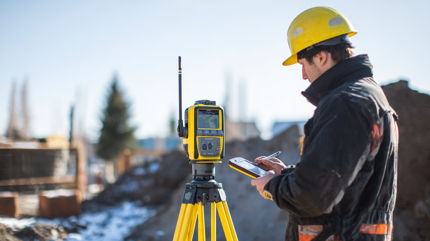
You know, Global Navigation Satellite System, or GNSS for short, really changed the game when it comes to surveying. It’s this whole network of satellites orbiting overhead that send out signals to give us pretty darn precise location info all around the world. But then there's DGPS — Differential GPS — which kind of takes things up a notch. It relies on ground-based reference stations to refine the satellite signals, fixing issues that can pop up due to weather, buildings, or obstacles that mess with the signals. Getting a handle on these basics is super important when you’re trying to pick out the right gear for your survey projects.
When you’re shopping for a GNSS or DGPS device, it’s worth thinking about just how accurate you really need it to be. DGPS can be a real lifesaver in tricky spots like city centers with tall buildings or dense forests where GNSS alone might not cut it. Plus, consider how reliable the satellite signals are, and what you’re actually planning to do — whether it’s construction, land surveying, or environmental work. Once you get the hang of how these systems work, making the right choice becomes a lot easier. It helps you pick equipment that matches your goals, so you get the best results, every time.
Key Factors to Consider When Choosing Survey Instruments
When you're choosing a Gnss Dgps Survey Instrument for your project, it’s pretty important to think about a few key things that can really make a difference in how accurate and efficient your survey turns out. First off, you wanna get a clear idea of how precise you need your measurements to be. Different jobs call for different levels of accuracy—so, are you aiming for sub-meter or even centimeter-level precision? Knowing this upfront can save you a lot of trouble later on.
Pro tip: Make sure your accuracy needs line up with what your project actually involves. Whether you’re doing land surveys, mapping, or construction work, pick a tool that does the job well without breaking the bank.
Another thing to keep in mind is how well the device plays with your existing equipment and software. It’s worth double-checking that the GNSS DGPS receiver you pick can integrate smoothly with what you already have. This way, you avoid wasting time on complicated setups or data issues. Also, look into what data formats it supports and if it plays nice with other survey tools you use—that stuff matters when it comes to collecting and analyzing your data without headaches.
Tip: Go for models that offer flexible connectivity options. It’ll save you a lot of hassle down the line if your gear plays well together from day one.
Comparing Different Types of GNSS DGPS Survey Instruments
When you're trying to pick the right GNSS DGPS survey tool for a project, it’s really important to get a good handle on the differences between the options out there. Recent studies from around the world actually show that the kind of instrument you choose can make a big difference in how accurate and effective your survey turns out. For example, some devices are built for super precise work—think civil engineering or construction projects—while others are perfectly fine for simpler tasks like mapping out land topography.
When comparing different GNSS DGPS survey units, it’s helpful to consider factors like the environment you’ll be working in, how precise you need the data to be, and what kind of info you’re collecting. Some models come with fancy features like real-time kinematic positioning, which really boosts accuracy and makes life easier in tricky terrains. On the other hand, there are budget-friendly options that perform just enough for everyday surveying. Knowing these little differences can really help professionals pick the right tool for the job, making sure they get the best results without wasting resources.
Essential Features to Look for in a Survey Instrument
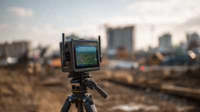
When you're choosing a GNSS DGPS survey device for your project, it's pretty important to focus on the key features that can really make a difference in how accurate and efficient your survey turns out. First off, you wanna look for receivers with solid signal processing power. The best ones support multiple frequency bands, which helps track satellites better—especially in tricky spots like urban canyons or places with lots of trees. Having this feature means you'll get more reliable data and better positioning accuracy overall.
Another thing to keep in mind is how user-friendly the device is. A simple, easy-to-navigate display and intuitive software can save you a lot of headache and boost productivity, especially if your team has folks with different levels of experience. It's also smart to check if it plays nicely with various data formats and software — that way, integrating everything with your existing workflow isn’t a hassle. And don’t forget about battery life and durability. Your equipment needs to survive rough conditions out in the field and last long enough to get through your entire survey without dying on you halfway through.
Assessing Budget and Cost-Effectiveness for Your Project
When you’re choosing a GNSS DGPS survey device for your project, it’s really important to think about your budget and how cost-effective your options are. I’ve read from NOAA that good planning can actually cut your total project costs by up to 30%. It’s crazy how much you can save just by doing a little homework beforehand. The price for GNSS gear can vary a lot — from a few thousand dollars to over fifty grand — depending on the features you need and how precise you want things to be. Knowing how these costs fit into your overall budget helps prevent overspending or ending up with a piece of equipment you’re not really using to its full potential.
Also, don’t forget to look beyond the initial purchase price. Maintenance, training, software licenses, and possible upgrades can add quite a bit to the total cost over time. According to the International Society of Automation, these ongoing expenses can increase your annual costs by around 15-20%. Because of that, when you’re eyeing a particular device, it’s smart to think long-term and consider how these extra expenses will play out down the line. By keeping all of this in mind and balancing your priorities, your team can run smoother projects and get the most bang for your buck on GNSS DGPS tech.
Cost-Effectiveness of GNSS DGPS Survey Instruments
This bar chart illustrates the cost and accuracy of four different GNSS DGPS survey instruments. As seen, while Instrument B has the highest cost, it also offers the best accuracy. Instrument A is more cost-effective with good accuracy, making it a viable option for budget-conscious projects.
Best Practices for Implementing GNSS DGPS in Field Surveys
When you’re setting up GNSS-DGPS for field surveys, it’s really important to think through a bunch of different factors that could impact how accurate and reliable your data is. I’d read somewhere recently, from the International Federation of Surveyors, that using GNSS tech can bump up the positioning precision to just a few centimeters — which is pretty crucial whether you’re working on construction sites, farming projects, or environmental studies. So, picking the right GNSS-DGPS device honestly depends on what your project needs. Things like how precise you need to be, what kind of environment you’re dealing with, and your budget all come into play.
Most experts suggest people do a solid plan beforehand — really think about what they want to achieve and what hurdles might pop up. For example, if you’re working somewhere with a lot of signal interference — think urban full of buildings, or in thick forests — then it’s worth choosing receivers that are better at dealing with multipath issues. Also, it’s super helpful if your team stays trained and familiar with the gear. That way, they’re more prepared to handle any signal dropouts, which, by the way, has been a hiccup in places like the Persian Gulf affecting marine traffic. Oh, and don’t forget: keeping your Gnss Equipment well-maintained and regularly calibrated makes a big difference in keeping things running smoothly and making sure your data is spot-on in the field.
How to Choose the Right GNSS DGPS Survey Instrument for Your Projects
| Instrument Type | Frequency | Typical Accuracy | Data Collection Rate | Battery Life | Weight |
|
Rtk Gnss Receiver | L1, L2 | 1-3 cm | 1 Hz | 8-12 hours | 1 kg |
| Post-Processing GNSS Receiver | L1, L2, L5 | 2-5 cm | 0.2-1 Hz | 12-24 hours | 1.5 kg |
| Handheld GNSS Receiver | L1 | 5-10 m | 1 Hz | 20-30 hours | 0.5 kg |
| Surveying GNSS Receiver | L1, L2 | 3-5 cm | 1 Hz | 10-15 hours | 1.2 kg |
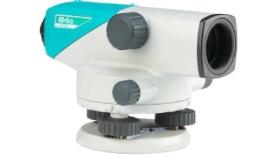
Achieving Accurate Measurements with the High Precision 24X Sokkia B40 Auto Level Survey Instrument
The High Precision 24X Sokkia B40 Auto Level Survey Instrument stands out as a remarkable tool for professionals seeking accuracy and efficiency in their leveling tasks. With a magnification of 24X and a superior telescope, users can achieve quick collimation, making it easier to set up and get to work. This feature not only enhances the speed of the setup but also improves the overall precision of measurements, ensuring that every detail is captured accurately.
One of the standout features of the Sokkia B40 is its reliable automatic compensator, which guarantees precision across various terrains. With an impressive accuracy of ±2mm (0.08 in.) when conducting a 1km double run leveling, this instrument meets the stringent requirements of construction, engineering, and land surveying professionals. Furthermore, the rapid and easy horizontal angle measurement capabilities streamline the surveying process, enabling users to complete their tasks efficiently without compromising on quality. The Sokkia B40 is designed to assist users in achieving the most reliable results with minimal effort, making it an essential addition to any surveying toolkit.
FAQS
: GNSS DGPS survey instruments are used for accurate surveying tasks in various applications, including civil engineering, construction, topographic mapping, agriculture, and environmental monitoring.
The right instrument should be selected based on project requirements, including required accuracy levels, environmental conditions, and budget constraints.
Factors such as environmental conditions, required accuracy levels, and the type of data to be collected significantly impact the effectiveness of GNSS DGPS surveying.
Real-time kinematic positioning is an advanced feature that enhances accuracy and efficiency in GNSS surveying, especially in challenging terrains.
Signal interference, particularly in urban areas or dense forests, can hinder data accuracy. Using receivers with higher multipath mitigation capabilities can improve data fidelity in such environments.
Ongoing training ensures that survey personnel are familiar with the equipment, allowing them to troubleshoot potential DGPS signal loss issues effectively.
Proper maintenance and regular calibration of GNSS systems are essential to maximize their performance and extend their service life.
Integrating GNSS technology can enhance positioning accuracy to within centimeters, which is critical for various applications.
Some instruments are designed for high-precision tasks while others are more cost-effective, providing adequate performance for general surveying needs.
Reports of signal disruptions, such as those experienced in the Persian Gulf, have highlighted the need for robust equipment to ensure reliable marine operations.
Conclusion
Hey there! So, in this blog called "How to Pick the Perfect GNSS or DGPS Survey Device for Your Projects," we’re diving into what really matters when choosing the right tools for your geospatial work. Honestly, understanding the basics of GNSS and DGPS tech is super important—it really can make a big difference when it comes to getting accurate results out in the field. When you're trying to decide, think about what your project needs most—what kinds of instruments are out there, and which features matter to you? Things like precision, how easy they are to use, and if they’re built tough enough to handle the job are all key points to consider.
Of course, your budget plays a big role too. You want to find something that’s not just good, but also worth the money. When you follow best practices for using GNSS DGPS devices, it can really boost both the accuracy and efficiency of your surveys. Here at Shanghai Apekstool (APEKS), we’re all about offering smart solutions that fit your mapping and surveying needs. We hope to be your go-to partner for all your geospatial projects—it’s what we do best!